Tag: science

  • (Keep Feeling) Flocculation

    The latest aspect of hiking and camping that I have been spending way, way too much time researching is water filtration. I need to decide on which brand and what size of filter to purchase. However, while comparing different products, I got sucked into a rabbit hole while looking at one particular product.
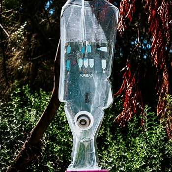
    Puribag is a water purification system that purports to take the dirtiest, most rancid water you will ever hope to find, and somehow render it potable. The way it works is you full this giant 2.5 gallon (10 liter) bag with the water and then dump in a purification packet and shake vigorously for 5 minutes. Then you hang the bag from a tree or something. After 30 minutes the impurities in the water clump together and sink to the bottom of the bag. Once that happens you clip the debris to segregate it from the rest of the clear water and dump it out. Then you can open the tap and drink it or use it to cook with or whatever you want to do with it.

    The rabbit hole I fell into was researching how the system works. I mean, I know how it works. I just described it. I mean how the how part works. What exactly is the purification packet? How does the packet make the dirty part of the water clump together like that? How does it know? Magic, or science, or a little bit of both? To answer those questions we have to dig a little deeper into how drinking water is processed and the power of inorganic chemistry.
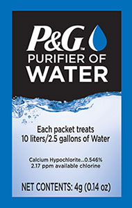
    The first thing you notice when you look at the front of the packet is that it contains calcium hypochlorite. But that wouldn’t have any role in causing the clumping of material we see in the video above. The second thing you notice on the front of the packet is the amount of calcium hypochlorite, 0.546%. In other words, 99.454% of this stuff is something other than calcium hypochlorite. What is that something else? We need to look elsewhere for the answer.
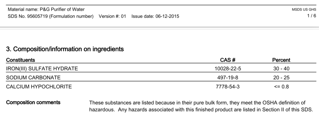
    Fortunately, I found a safety data sheet (SDS) for the P&G purifier of water online. It shows that 30-40% of what’s in the packet is iron(III) sulfate hydrate, also called ferric sulfate. The ferric sulfate is the secret sauce that does most of the heavy lifting. The 20-25% sodium carbonate in the packet keeps the overall pH within an optimal band to allow the magic to happen.

    When ferric sulfate is added to water the first thing it does is dissociate into positive ferric ions and negative sulfate ions. Since water is highly polar, particles suspended in it tend to be negatively charged. This negative charge electrostatically repels the particles from each other and is one big reason everything dissolves in water so well. The ferric ions adsorb to these molecules and neutralize their charge, allowing them to coagulate.

    At this point we need to go back to that snapshot from the SDS. Notice how the combined weights of the iron sulphate, sodium carbonate, and calcium hypochlorite only equals from 50-65% of the total mix. That’s because the SDS will only include potentially hazardous materials. A quick read of the patent application for the P&G purifer of water tells us that it also contains materials like chitin, clay, and cellulose. These ingredients will aid in flocculation.

    Flocculation is the fancy term for the aggregation and sedimentation of particles from a colloid. To dumb that down another couple of grade levels, it is when a bunch of tiny stuff in a suspension clumps together and slowly falls out of solution. The flocculants from the previous paragraph are mostly water-insoluble and comprised of polymers that give them a large size. As such, they can sweep through the water like big sails and present attachment points for the coagulated particles.

    As coagulated particles combine with flocculants, they form “flocs”. Flocs get bigger and bigger as they join hands with more and more particles and other flocs. Eventually the flocs become so big that their density causes them to sink to the bottom of the bag.

    After this step most of the foreign organic and inorganic matter has been removed from your water. This includes heavy metals like arsenic, as well as parasitic cysts such as Cryptosporidium parvum. Once all this stuff has precipitated out, the calcium hypochlorite gets its turn to shine.

    The only ingredient actually listed on the front of the packet is used as a disinfecting agent. It is coated with a hydrophobic material like wax, so that it does not release as soon as it gets added to the water. It bides its time for the first five or ten minutes and then enters the fray to take care of bacteria and viruses only after everything else has been successfully bound. The majority of the 30 minute wait time is to allow this critically important step to complete.

    Once the debris gets dumped from the Puribag the water is ready to be enjoyed. The final step is passing it through a filter on the spigot. That filter is a 0.1 micron hollow filter using activated carbon from coconut shells. Yes, you read that correctly, coconut shells. The preparation of shells to transform them into usable filters is also a multi-step process.

    First, the inner portion of the shell is separated out and then it is cleaned, dried, and crushed into small pieces. The pieces are then heated at hundreds of degrees in a low oxygen environment in a process called pyrolysis. After pyrolysis the coconut shells transform into charcoal. Then the charcoal is activated with steam to open additional pores in the carbon. Once activated, the extra pores create untold surface area on the charcoal. One teaspoon of which can contain as much area as a football field. This large surface area adsorbs any molecules that might still be left in your treated water. Chiefly, it will capture molecules that might have unpleasant tastes or odors. The extraordinary adsorptive properties of activated charcoal are why it is used to treat poison victims. The charcoal can compete to suck up the poison before all your squishy and important vital organs do.

    This water purifying technology is not really very applicable to hiking. Rarely would you ever need to purify 2.5 gallons of water at once, unless you were responsible for getting potable water for your whole tramily. It is definitely possible to purify more water than you need at once and carry it around with you. Keeping in mind that water weighs approximately 8 pounds per gallon, you are talking about up to 20 extra pounds in your load. Not something most people would willingly agree to when life straws, one liter purifiers, and boiling exist.

    Camping is a fantastic use for this product. You can set up camp and get a couple gallons of water ready within an hour. But you know who really makes great use of the purifier of water packets? Third world countries.

    Here is another video that includes an interview with the inventor of the purifier packets. He talks about the three-step process of coagulation, flocculation, and disinfection (starting @ 3:41). Fair warning, this video does contain a jump scare with admitted adulterer and Epstein associate Bill Gates @ 5:25.

    Phil Souter was in laundry research in the 1990s when he came up with the idea that would become the P&G purifier of water. That satchet makes it possible to generate 2.5 gallons of clean water from inputs of dirty water, a bucket, a spoon, and a cloth to use as a makeshift filter. Dr. Souter received an Order of the British Empire for his work. P&G helped establish Children’s Safe Drinking Water, a charitable arm that gives away purifier packets to communities in need of them. They have worked to clean over 25 billion liters of water around the world.

    I spent a fair amount of time in this rabbit hole, reading patent applications and scientific papers, just because I found the story so enthralling. The science underpinning it is intriguing as well. In the words of Marge Simpson, I just think they’re neat! Now I need to get back to analyzing the different trade-offs between LifeStraw and Grayl.
  • How to Navigate Without GPS or a Compass

    Here is something that is tangentially related to hiking. Do you have any idea how to find your bearings and direction if your compass and GPS stop working? Obviously you can, because people did just that long before compasses and GPS were a thing. Polynesian seafarers successfully navigated the open Pacific 5000 years ago. That was way before Waze.

    Here I’ll provide some tips that should help you survive in the worst possible hiking scenario: you get totally lost and have no power or compass. None of these methods will drop a giant pin where you need to go, but they will keep you alive if used correctly.

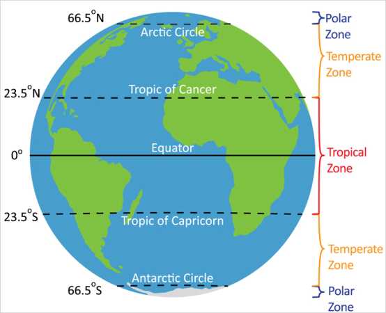
    Before we start I want to go over some terminology you will need to understand in order for these lessons to make any sense. Firstly, the Earth is a sphere. Sorry flerfs. The equator goes around the middle of the earth and divides it into northern and southern hemispheres. North America, Europe, the Middle East, and continental Asia are all entirely located within the northern hemisphere. Australia, Antarctica, almost all of South America, and about a third of Africa are in the southern one. If you are familiar with African geography, Lake Victoria sits just about right at the equator.

    Lines of latitude run east-west and divide the earth. The equator sits at 0 degrees latitude with the north and south poles at 90 degrees north and south respectively. 23.5 degrees north of the equator is a line of latitude called the Tropic of Cancer. Similarly, the Tropic of Capricorn sits at 23.5 degrees south latitude. The region between them is unsurprisingly called the tropics. The other important lines of latitude are the Arctic and Antarctic Circles, sat at 66.5 degrees north and south respectively. Everything north of the Arctic Circle or south of the Antarctic Circle is called polar regions. Everything between the tropics and the polar regions is known as the temperate region. Although I’m not sure how many people would describe Duluth, MN in the winter as “temperate”.

    Image shamelessly borrowed from https://www.climatechange.edu.hk

    Thanks for bearing with me on that. It is important because some of these methods will or won’t work in certain regions because of spherical geometry. There are also quite a few cases where you’ll need to do something one way in one hemisphere and then do it “backwards” in the opposite one.

    Generally speaking the best conditions in which to have no idea where you’re at are clear, sunny days. Barring that, the next best thing is a cloudless night with as many stars visible as possible. The worst conditions are overcast days and nights. This makes sense since the main ways to orient yourself involve using the sun and prominent stars. With that in mind, we’ll go over tips that you can use when conditions vary from best to worst.

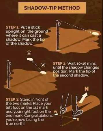
    First up is the shadow tip method. This works during the day and you only need enough sun to be able to cast a shadow, even if it is a faint or intermittent one. Place a stick vertically into the ground and put a small rock where the end of the shadow falls. This is your WEST. Wait patiently for 15 minutes or so until the shadow has moved a few inches and then place another rock on the new shadow tip. This is your EAST. Draw a line between the two rocks. Stand with your left foot on the west rock and your right foot on the east rock. Straight ahead is NORTH and behind you is SOUTH.

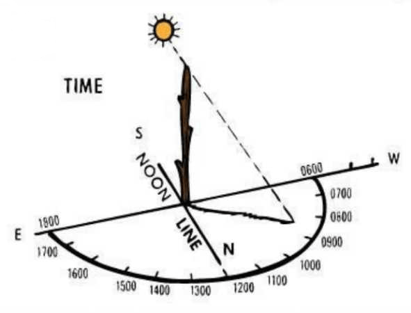
    You can draw a north-south line perpendicular to your east-west line. Put a second stick vertically into the ground at the intersection of those lines. Cant the stick slightly towards north in the northern hemisphere or towards south in the southern hemisphere. Draw a semicircle going from 0600 in the WEST to 1800 in the EAST. The shadow of that second stick will give you a rough approximation of the current hour. This method is more accurate the closer it is to noon and the closer you are to an equinox.

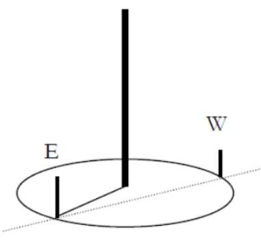
    There is an advanced version of the shadow tip method called equal shadow method. For this to work, you need to begin within ten minutes before solar noon (when the sun is at its highest point). Just like before you put a stick in the ground, but you need to make sure the shadow it casts is no more than 12 inches long. Mark the tip of the shadow with a rock; this will represent WEST again. Using a piece of string, trace a circle around the stick with radius equal to the length of the shadow.

    As noon approaches, the shadow will decrease in length and then start to increase again. Mark where the shadow touches the circle again; this is EAST. From here you can discern NORTH and SOUTH the same way as before.

    Pilfered from Scout Society

    Equal shadow method is more accurate than shadow tip, but at the cost of taking longer, using an extra piece of string, and needing to be done at a certain time of day. Both shadow tip and equal shadow can be done anywhere on earth, but they are much less reliable in the polar regions due to the position of the sun in the sky.

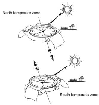
    Maybe you don’t like sticks. Then this next method is for you. It is called the watch method. You need to be able to read an analog clock face, which might eliminate any readers under the age of 35. If you do not have a watch, you can draw a picture of a watch showing the current time so you still need to know the exact time. One last thing is you need to be using standard time, so if you are on daylight savings then move the watch back one hour.

    This is hemisphere dependent. If you are in the northern hemisphere, take your watch or picture of the clock face and aim the hour hand at the sun. Midway between the hour hand and 12 will be SOUTH. If you are in the southern hemisphere, point 12 at the sun. Midway between 12 and the hour hand will be NORTH. This method requires you to be able to see the sun and only works in the temperate zones.

    Next up, let’s go over what you do during the roughly 50% of the time that there is no sun. At night your best friends will be the North Star and the Southern Cross.

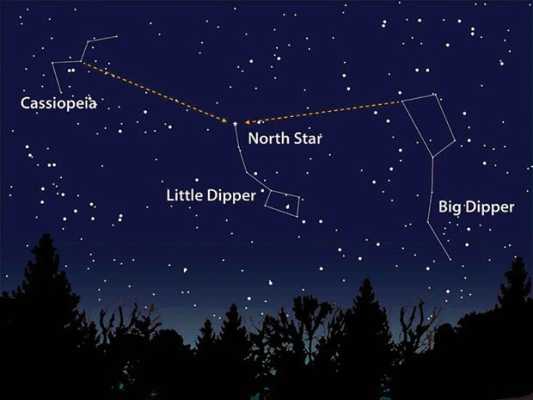
    The North Star (Polaris) is a part of the Little Dipper (Ursa Minor) constellation and always sits in the direction of NORTH. A good way to find it in the night sky is to remember that it sits as many degrees above the horizon as degrees you are above the equator. For example, at the north pole Polaris is directly overhead (90 degrees) and at the equator it sits right on the horizon (0 degrees). In Austin you can find it about 30 degrees above the horizon, or a third of the way up. Once you find the North Star you can use it to orient yourself and find the other cardinal directions.

    This picture was horked from Moab Happenings

    The Southern Cross (Crux) is a constellation seen only in the southern hemisphere. But if you’ve ever seen the Australian flag you know what it looks like. Fortunately, it contains four of the brightest stars in the southern hemisphere. Now it would be very simple and elegant if I could tell you something like how the Southern Cross sits exactly at south the same way Polaris sits at north. Sadly, this is anything but simple and elegant.

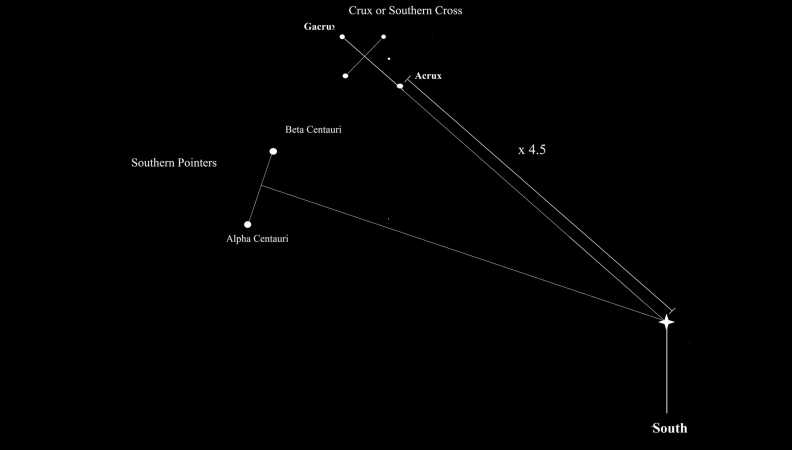
    To find south using the Southern Cross you have two options. First, you can extend the long axis of Crux out for another 4.5 lengths and that will end above south. If you don’t want to do that, you will need to find another constellation called Centaurus. Two stars in Centaurus (Alpha and Beta Centauri) can be used as pointer stars. Draw an imaginary line segment between those two stars. Extend a perpendicular line from the midpoint of that segment; where it crosses the extended long axis of Crux will be SOUTH.

    We lifted this from https://blog.woodland-ways.co.uk while they weren’t looking

    Like I said, this method is anything but simple and elegant. For the sake of simplicity, try to get hopelessly lost at night in the north if you can. Both of these methods work in any region but the constellations are tougher to see the closer to the equator you are. Also, you should stop and recalibrate often, especially in the southern hemisphere.

    The next nighttime navigation method requires more materials but does not require you to identify any stars or calculate the lengths of any major axes. It also works the same way in both the northern and southern hemispheres. This method is called LURD, which stands for Left Up Right Down.

    You identify a star, pretty much any star except Polaris. Place a stick vertically into the ground so that its tip is at eye level while seated. About 2 feet or so is an ideal stick length. Pick your star of interest and line it up so it is at the tip of the stick while you are seated. Now take a second stick, about 3-4 feet long. Line that stick up behind the first one so that the star is located on the tip of both sticks while you are seated.

    Illustration swiped remorselessly from https://www.grit.com

    Good. Now wait about thirty minutes. In that time, your star of interest will have moved. Figure out which way it moved and use LURD to figure out which way you are facing.

    • If the star moved LEFT, you are facing NORTH
    • If the star moved UP, you are facing EAST
    • If the star moved RIGHT, you are facing SOUTH
    • If the star moved DOWN, you are facing WEST

    If the star moved up and right, it means you are facing to the southeast. If it moved left and down, you are facing northwest. This method consumes a lot of time both in the waiting for the star to move and in setting up the two sticks correctly.

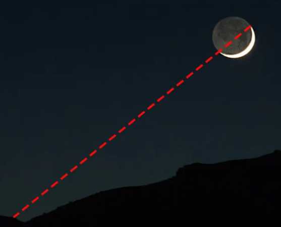
    There is one last method you can use on a clear night. This is called horns of the moon. This only works during a waxing or waning crescent moon, which is about one quarter of the time. Draw an imaginary line between the two tips of the crescent moon and extend that line down to the horizon. In the northern hemisphere, that point on the horizon will be SOUTH. In the southern hemisphere that point will be NORTH. Doesn’t work during a full moon for reasons that should be obvious.

    Now let’s look at what to do if it is too cloudy to see the sun or the stars. Your best bet is to use clues from nature. These are obviously going to lead to sub-optimal results, so anything you glean should be double checked as soon as you can get somewhere without cloud cover.

    Firstly, a “DON’T”. Don’t use the old wives’ tale about moss growing on the north side of trees. Moss is promiscuous and grows everywhere it feels like, as long as it gets enough sun. Seeing moss is not a reliable enough indicator of north to start trekking off in whatever direction it indicates.

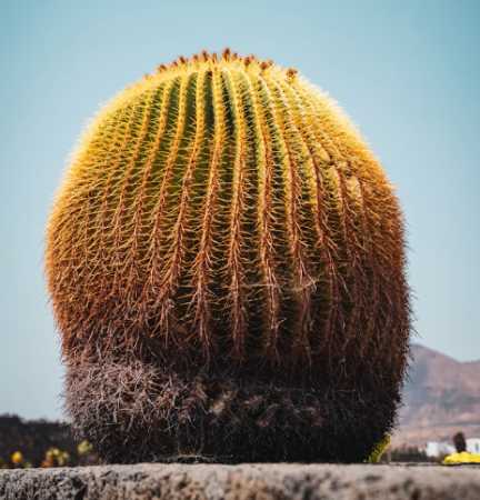
    In the early summer, north-facing hillsides will retain snow longer than southern facing ones in the northern hemisphere. In the southern hemisphere, the opposite is true. Tree stumps will have wider spaced growth rings on whichever side faces the equator. So, south in the northern hemisphere and north in the southern. Barrel cacti in the Mojave (southwestern USA) grow towards the south.

    Lastly, I’m going to discuss improvised compasses. I am going to talk about these last because I have the least amount of confidence in this method of finding your bearings. Basically, only try this if every single method listed above has proven ineffective. I have never gotten an improvised compass to tell me anything useful about which way anything was.

    You can magnetize a needle by rubbing it with a magnet or, barring that, a piece of silk or fur. You will need to rub the needle at least 50 times in the same direction in order to magnetize it. Then you will want to carefully lay the magnetized needle on top of a leaf in a puddle or pool of water. If you wait, the needle will align itself along a north-south line.

    For obvious reasons, the puddle or pool needs to be as far removed as possible from any metallic or magnetic items like cars, camping gear, bleachers, or the magnet you used to magnetize it in the first place. Again, I have never gotten this to work for me. But if you are so desperate you got all the way to this part of the post, you might as well try it.

    One last thing. I used some pictures here that I got from ATP 3-50.21, an Army Training Publication that is freely available to the public. It has to do with survival in all sorts of conditions and I’d recommend downloading it. Doubly so if you plan to find yourself in an Alive or The Mountain Between Us type situation.